ALGECIRAS · RECORRIDO A PIE
Paco de Lucía: de la Bajadilla a su legado
La infancia abre el relato en la Bajadilla; el jardín y el centro histórico permiten descubrir la ciudad que acompañó al guitarrista. La última parada vuelve hacia Ruiz Zorrilla para cerrar el paseo en el Centro de Interpretación, donde calles y recuerdos se convierten en música. Organiza la salida según la apertura de la exposición.
Media jornada, incluyendo paseo y exposición · 6 paradas
Favourites and visits are saved only in this browser. They do not sync across devices.
TU PASEO, PARADA A PARADA
Abre el recorrido y empieza a caminar
Las paradas se visitan en este orden. Google Maps calcula el camino peatonal; las indicaciones de cada tramo te cuentan qué buscar al llegar.
0 de 6 paradas visitadas · guardado en este dispositivo
En recorridos largos dividimos el enlace para conservar todas las paradas en móvil. Comprueba aperturas y señalización; la navegación puede variar por obras o accesos.Read the transcript
Paco de Lucía: from La Bajadilla to his legacy
Childhood opens the story in La Bajadilla; the garden and historic centre reveal the city that accompanied the guitarist. The final stop returns towards Ruiz Zorrilla to finish at the Interpretation Centre, where streets and memories become music. Organise departure around the exhibition's opening hours.
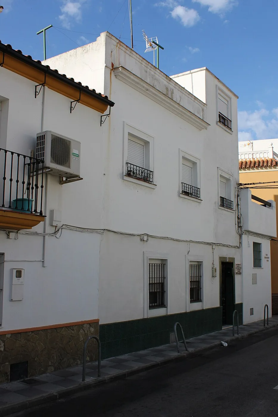
Calle San Francisco offers an intimate beginning to the Paco de Lucía route. Here the visit is not about finding a great monument, but recognising that a universal story can begin in a neighbourhood street. The contrast between the scale of the place and the stature of the musician is precisely what makes the stop meaningful. The municipal route places the birth of Francisco Sánchez Gómez in 1947 at number 8 and recalls that he lived there until the age of five. Afterwards, the family moved to another street in La Bajadilla. This point speaks of childhood and surroundings; his artistic development is better understood by completing the visit with the interpretation centre, where his training and career receive specific attention. Look for the commemorative plaque and observe the street's setting from public space. Do not assume that a house associated with a famous person functions as a museum. The value of this stop lies in locating the beginning of the story, not entering an interior. Consider for a moment the difference between biographical memory and a museum exhibition: both can form part of a journey, but are visited differently. Respect doors, windows and residents' lives. From here, the municipal guide leads along Fuentenueva towards Plaza de Andalucía and then along Blas Infante towards the centre. Our itinerary uses this urban continuity and includes pauses so the walk is not a race between markers. Wear comfortable footwear and adapt your pace to the slopes.
From Calle San Francisco, follow the connection described by the municipal route: Fuentenueva, Plaza de Andalucía and Blas Infante. At Parque María Cristina, enter through an open entrance and pause in the garden.
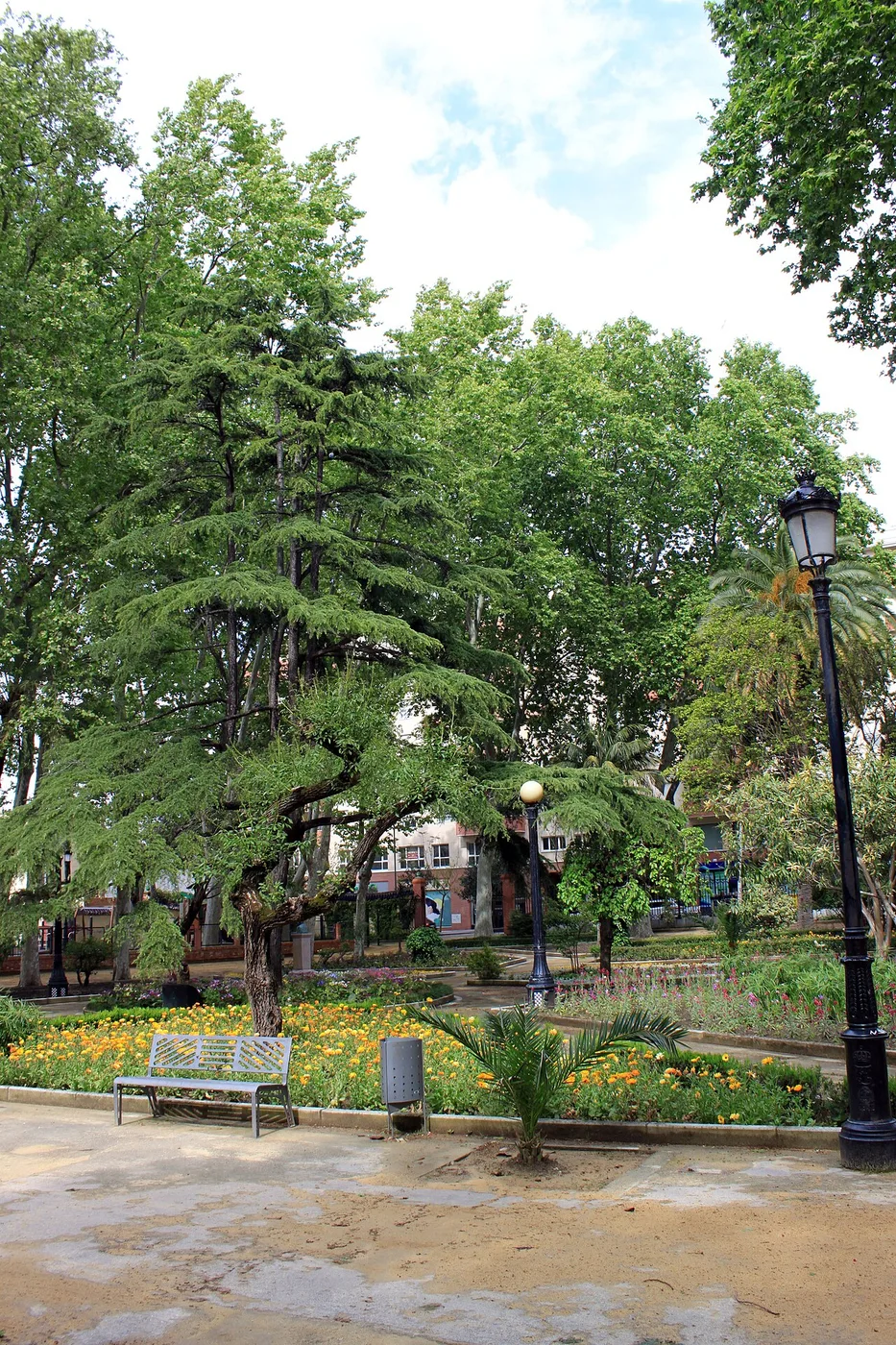
Parque María Cristina offers another reading of the centre: walks that need no destination. Entering changes the scale of the journey. After squares and façades, your attention turns to trees, paths and the possibility of sitting for a while before continuing to discover Algeciras. Its origins go back to 1834, when it was created on land donated by Agustín Bálsamo at General Canterac's request. The initial design followed the geometry of French gardens, with intersecting straight paths. It began outside the urban core of the time and now makes it possible to appreciate how much the city has grown around it. The municipal account includes it within Andalusian historic heritage as a garden of cultural interest. Walk along a main axis and then take a cross path: this makes the garden's structure easier to recognise. Observe how vegetation changes the light and how seating areas distribute the life of the park. Rather than seeking a single spectacular tree, try to read the whole as living architecture, where perspectives and pauses are also part of the design. This is a good stop between La Bajadilla, the walls and the historic centre. You can make a quiet visit or include it as a rest in a longer cultural itinerary. Check that day's access if coming at an unusual time; an urban garden does not have the same conditions as a square that is always open. Do not assume a concert is scheduled without consulting the programme.
Leave towards Blas Infante and follow pavements and designated crossings to the wall complex. Around Comandante Gómez Ortega, you can recognise the former Calle Munición before resuming the route.
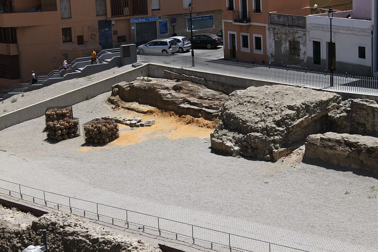
Among today's streets, a different Algeciras appears: a city that needed to control its entrances, defend its port and negotiate its place between two shores. The medieval walls are not a backdrop for a quick photograph. They invite you to imagine crossing an urban boundary when a gate had military importance. The surviving complex belongs to the Marinid fortification built between 1279 and 1285. Its remains reveal stretches of wall, towers, an outer wall and a moat, as well as the entrance associated with the Puerta del Fonsario. The name refers to the cemetery outside the enclosure. The destruction of the city in the fourteenth century and the later reoccupation of its site explain why we now read the defensive system through fragments and excavations. Begin by looking at the distance between the wall and the moat. Then identify the changes of direction in the approach: what matters is not just a wall's height, but how it controls the movement of someone trying to enter. Compare the remains with the level of modern streets to perceive the layering of cities. Follow the panels and distinguish original remains from later presentation work. The municipal walk connects the Alfonso XI area with Avenida Virgen del Carmen. Explore the designated areas and check the interpretation centre's opening times if you want to extend the visit. From here, Plaza Alta forms a logical continuation through the city; the contrast between medieval fortification and modern square is one of the best introductions to local history.
Take Alfonso XI towards Plaza Alta. This urban leg connects medieval memory with the city's everyday centre; on arrival, spend time enjoying the square's atmosphere.
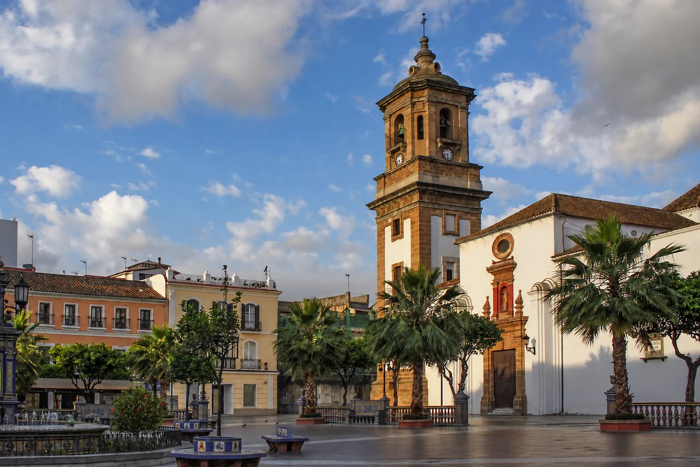
Algeciras is easier to understand when you stop simply passing through and learn to linger. Plaza Alta invites you to do just that: sit down, watch the streets meet and discover a city in conversation around its most recognisable space. Ceramics and religious façades turn an everyday pause into a first lesson in urban history. The square was laid out in 1807 on the initiative of General Castaños and was initially called Plaza del Almirante. Its obelisk disappeared in 1926; three years later, the ceramic paving was commissioned from workshops in Seville. This succession of alterations and names explains why the place is the creation of many eras, rather than an untouched scene from the past. The city has recorded its political changes and its ways of occupying public space here. Walk around once to take in the whole square, then again to follow the details in the paving. Compare the presence of La Palma with the more intimate scale of the Europa chapel: two ways of giving shape to the same square. Then find a bench overlooking the entrances of the streets. The visit becomes richer when you also watch the comings and goings of those who use this place every day. Allow yourself a proper pause before continuing towards the market or San Isidro. You can visit the square regardless of whether the churches are open; if you want to enter them, check their opening times separately. This is the best place to begin the centre's monumental walk and return to when you finish.
From Plaza Alta, continue along Radio Algeciras and descend Calle Real to the market. This is the municipal route's connection; observe the architecture and, if open, life at the stalls.
At Mercado Ingeniero Torroja, it is worth making two visits at once: one with your eyes on the roof and another at stall level. Few buildings explain so well how a great work of architecture can belong to a city's daily shopping, working life and conversation. Built in 1935, the market brings together Eduardo Torroja's engineering and the contribution of architect Manuel Sánchez Arcas. Its octagonal plan is covered by a concrete shell almost 48 metres in diameter, supported by eight peripheral pillars. This solution frees the interior space and turns a commercial requirement into a landmark of Spanish Rationalism. It was declared a Bien de Interés Cultural in 2001. Find a position from which your eyes can follow the roof all the way to its supports. The sense of spaciousness depends precisely on what is absent from the middle: a succession of supports interrupting the space. Then look again at the entrances and the relationship with the square. The architecture does not end at the roof; it also organises how buyers and sellers enter, meet and move around. If you want to see the market working, check opening times and plan a morning stop. Buy something if you wish, and ask permission before photographing people or stalls at close range. From Plaza Alta, you can descend along Radio Algeciras and Real; continuing afterwards towards La Caridad takes you from the commercial city to its cultural collections.
To finish at the Interpretation Centre, return along Real and Radio Algeciras to Plaza Alta, then follow Alfonso XI to Blas Infante. Continue on pavements towards Ruiz Zorrilla, 3, at the corner with Blas Infante. This final leg retraces part of the walk: allow time for the return and exhibition, using marked crossings.
After exploring streets associated with Paco, the Interpretation Centre lets you change the question: from where his music came from to how it transformed the guitar. This is a stop for pausing the walk and devoting time to listening, observing and recognising a career that cannot be explained simply through a list of awards. The centre occupies a 1931 building formerly used for healthcare and later by the local police. Its exhibition spaces explore family training, musical creation and encounters with other performers. The displays bring together guitars, documents, audiovisual resources and items linked to his career, alongside an auditorium for activities. Reusing the building adds another layer of urban memory to the visit. Do not try to see everything at the same pace. First choose a section about his beginnings and then another on his artistic evolution; compare what changes between them. When looking at instruments, seek information about their provenance and connection to the musician. In audiovisual displays, listen to the explanations as well as the best-known extracts: that is often where the relationship between work, artistic decisions and the resulting sound emerges. Check the address and opening hours on the centre's page before organising the day: an outdoor route does not depend on them, but this stop does. Allow separate time for the exhibition and do not promise a concert without checking the programme. On leaving, resume your walk through the centre with a piece or an idea in mind; you will read the city differently.
Ubicación de las paradas. Para seguir el camino entre ellas, abre las indicaciones de cada tramo.
PARADA 01 · Algeciras
Calle San Francisco and memories of Paco
.JPG)
Calle San Francisco y memoria de Paco · Resized for the web · Images and licences ↗
La calle San Francisco ofrece un comienzo íntimo para la ruta de Paco de Lucía. Aquí la visita no trata de encontrar un gran monumento, sino de reconocer que una historia universal puede arrancar en una calle de barrio. El contraste entre la escala del lugar y la dimensión del músico es precisamente lo que hace significativa la parada.
La historia que estás viendo
La ruta municipal sitúa el nacimiento de Francisco Sánchez Gómez en 1947 en el número 8 y recuerda que vivió allí hasta los cinco años. Después, la familia se trasladó a otra calle de la Bajadilla. Este punto habla de infancia y de entorno; el desarrollo artístico se comprende mejor al completar la visita con el centro de interpretación, donde la formación y la trayectoria reciben un tratamiento específico.
Fíjate en este detalle
Busca la placa conmemorativa y observa el contexto de la calle desde el espacio público. No presupongas que una vivienda identificada por su relación con un personaje funciona como museo. El valor de la parada está en situar el comienzo de la historia, no en acceder a un interior. Dedica un momento a pensar en la diferencia entre memoria biográfica y exposición museística: ambas pueden formar parte del viaje, pero se visitan de manera distinta.
Respeta puertas, ventanas y la vida de los vecinos. Desde aquí, la guía municipal conduce por Fuentenueva hacia Plaza de Andalucía y después por Blas Infante hacia el centro. Nuestro itinerario utiliza esa continuidad urbana e incorpora pausas para que el paseo no sea una carrera entre marcadores. Lleva calzado cómodo y ajusta el ritmo a las pendientes.
Desde calle San Francisco sigue el enlace descrito por la ruta municipal: Fuentenueva, Plaza de Andalucía y Blas Infante. Al llegar al Parque María Cristina, entra por un acceso abierto y dedica una pausa al jardín.
Seguir este tramo en Google Maps ↗PARADA 02 · Algeciras
María Cristina Park

Parque María Cristina · Resized for the web · Images and licences ↗
El Parque María Cristina ofrece otra lectura del centro: la de los paseos que no necesitan una meta. Entrar aquí cambia la escala del viaje. Después de recorrer plazas y fachadas, la atención se dirige a los árboles, los senderos y la posibilidad de sentarse un rato antes de seguir descubriendo Algeciras.
La historia que estás viendo
Su origen se remonta a 1834, cuando se creó en terrenos cedidos por Agustín Bálsamo a petición del general Canterac. El diseño inicial siguió la geometría de los jardines franceses, con caminos rectos que se cruzaban. Nació fuera del núcleo urbano de entonces y hoy permite percibir cuánto ha crecido la ciudad alrededor. La referencia municipal lo incluye en el patrimonio histórico andaluz como jardín de interés cultural.
Fíjate en este detalle
Recorre un eje principal y luego toma un camino transversal: así resulta más fácil reconocer la estructura del jardín. Observa cómo la vegetación modifica la luz y cómo las zonas de estancia distribuyen la vida del parque. Más que buscar un árbol espectacular aislado, intenta leer el conjunto como una arquitectura vegetal, donde las perspectivas y las pausas también forman parte del diseño.
Es una buena parada entre la Bajadilla, las murallas y el centro histórico. Puedes dedicarle una visita tranquila o incorporarlo como descanso en un itinerario cultural más largo. Comprueba el acceso del día si vas a una hora poco habitual; las condiciones de un jardín urbano no equivalen a las de una plaza siempre abierta. No des por programado ningún concierto sin consultar la agenda.
Sal hacia Blas Infante y continúa por las aceras y cruces habilitados hasta el conjunto de las murallas. En el entorno de Comandante Gómez Ortega puedes reconocer la antigua calle Munición, antes de retomar el recorrido.
Seguir este tramo en Google Maps ↗PARADA 03 · Algeciras
Medieval walls

Murallas medievales · Resized for the web · Images and licences ↗
Entre las calles actuales aparece una Algeciras distinta: la ciudad que necesitaba controlar sus entradas, defender su puerto y negociar su lugar entre las dos orillas. Las murallas medievales no son un fondo para una foto rápida. Son una invitación a imaginar cómo se atravesaba una frontera urbana cuando una puerta tenía valor militar.
La historia que estás viendo
El conjunto conservado corresponde a la fortificación meriní levantada entre 1279 y 1285. Sus restos permiten reconocer lienzos, torres, antemuro y foso, además del acceso relacionado con la Puerta del Fonsario. El nombre alude al cementerio situado fuera del recinto. La destrucción de la ciudad en el siglo XIV y la posterior reocupación de su solar explican que hoy leamos el sistema defensivo a través de fragmentos y excavaciones.
Fíjate en este detalle
Empieza mirando la distancia entre la muralla y el foso. Después identifica los cambios de dirección del acceso: lo importante no es solo la altura de un muro, sino cómo condiciona el movimiento de quien intenta entrar. Compara los vestigios con el nivel de las calles modernas para percibir la superposición de ciudades. Sigue los paneles y distingue restos originales de intervenciones de presentación.
El paseo municipal vincula el entorno de Alfonso XI con la avenida Virgen del Carmen. Recorre las zonas habilitadas y consulta la apertura del centro de interpretación si deseas ampliar la visita. Desde aquí, Plaza Alta queda integrada en una continuación urbana lógica; el contraste entre fortificación medieval y plaza moderna es una de las mejores introducciones a la historia local.
Toma Alfonso XI en dirección a Plaza Alta. El tramo urbano une la memoria medieval con el centro cotidiano de la ciudad; al llegar, dedica tiempo al ambiente de la plaza.
Seguir este tramo en Google Maps ↗PARADA 04 · Algeciras
Plaza Alta
Modified viewpoint; some details may differ from the actual place. Images and licences ↗
Algeciras se entiende mejor cuando se deja de atravesarla y se aprende a quedarse. Plaza Alta invita justamente a eso: sentarse, mirar cómo se cruzan las calles y descubrir una ciudad que conversa alrededor de su espacio más reconocible. La cerámica y las fachadas religiosas convierten una pausa cotidiana en una primera lección de historia urbana.
La historia que estás viendo
La plaza se trazó en 1807 por iniciativa del general Castaños y recibió inicialmente el nombre de Plaza del Almirante. Su obelisco desapareció en 1926; tres años después se encargó a talleres sevillanos la solería cerámica. Esa sucesión de reformas y nombres explica que el lugar sea una construcción de muchas épocas, no una escenografía intacta del pasado. La ciudad ha ido escribiendo aquí sus cambios políticos y su manera de ocupar el espacio público.
Fíjate en este detalle
Haz una primera vuelta mirando el conjunto y otra siguiendo los detalles del pavimento. Compara la presencia de La Palma con la escala más recogida de la capilla de Europa: dos maneras de ordenar una misma plaza. Busca después un banco desde el que ver las entradas de las calles. La visita gana cuando se observa también el ir y venir de quienes utilizan este lugar todos los días.
Reserva una pausa real antes de continuar hacia el mercado o San Isidro. Puedes visitar la plaza sin depender de la apertura de los templos; si quieres entrar en ellos, comprueba sus horarios por separado. Es el mejor punto para comenzar el recorrido monumental del centro y regresar al terminar.
Desde Plaza Alta continúa por Radio Algeciras y desciende por calle Real hasta el mercado. Es el enlace que propone la ruta municipal; observa la arquitectura y, si está abierto, la vida de los puestos.
Seguir este tramo en Google Maps ↗PARADA 05 · Algeciras
Ingeniero Torroja Market
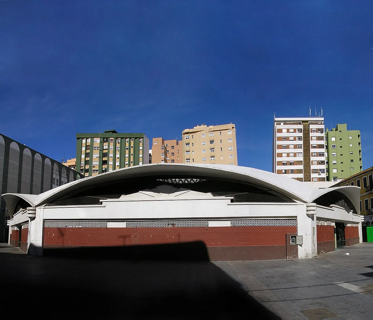

Mercado Ingeniero Torroja · Resized for the web · Images and licences ↗
En el Mercado Ingeniero Torroja conviene hacer dos visitas a la vez: una con los ojos puestos en la cubierta y otra a la altura de los puestos. Pocos edificios explican tan bien que una gran obra de arquitectura puede formar parte de la compra diaria, del trabajo y de la conversación de una ciudad.
La historia que estás viendo
Construido en 1935, el mercado reúne la ingeniería de Eduardo Torroja y la intervención del arquitecto Manuel Sánchez Arcas. Su planta octogonal se cubre con una lámina de hormigón de casi 48 metros de diámetro, apoyada en ocho pilares periféricos. La solución deja libre el espacio interior y convierte una necesidad comercial en un hito del racionalismo español. Fue declarado Bien de Interés Cultural en 2001.
Fíjate en este detalle
Busca un punto donde puedas seguir visualmente la cubierta hasta los apoyos. La sensación de amplitud depende precisamente de lo que no aparece en medio: una sucesión de soportes que interrumpa el espacio. Después vuelve a mirar los accesos y la relación con la plaza. La arquitectura no termina en su techo; también organiza cómo entran, se encuentran y circulan compradores y vendedores.
Si quieres conocer el mercado en funcionamiento, consulta sus horarios y plantea la parada por la mañana. Compra algo si te apetece y pide permiso antes de fotografiar personas o puestos de cerca. Desde Plaza Alta se puede descender por Radio Algeciras y Real; después, continuar hacia La Caridad permite pasar de la ciudad comercial a sus colecciones culturales.
Para cerrar en el Centro de Interpretación, vuelve por Real y Radio Algeciras a Plaza Alta y sigue por Alfonso XI hasta Blas Infante. Continúa por las aceras hacia Ruiz Zorrilla, 3, esquina con Blas Infante. Este último tramo recupera parte del camino: reserva tiempo para el regreso y para entrar en la exposición, respetando los cruces señalizados.
Seguir este tramo en Google Maps ↗